A screening‑level synthesis to support climate‑informed resilience decisions
Organizations today face an expanding set of climate‑driven risks — from flooding and extreme heat to infrastructure stress and community vulnerability. These risks are documented across a growing number of federal, academic, and nonprofit datasets. Yet decision‑makers are often left with fragmented signals, competing tools, and limited clarity on priorities.
Environmental Risk & Resilience (ER&R) is a screening‑level analytic framework designed to integrate, interpret, and contextualize existing risk information to support resilience‑oriented planning and decision‑making.
ER&R does not replace established tools or models. Instead, it helps organizations make sense of them — together.
ER&R synthesizes insights from multiple trusted public‑domain and third‑party sources — including federal indices and leading research datasets — to provide a coherent, cross‑hazard view of environmental risk and resilience at a screening level.
ER&R is designed to help organizations:
- Identify relative risk patterns and hotspots across geographies, portfolios, or service areas
- Understand how hazards, exposure, and vulnerability interact, rather than evaluating them in isolation
- Translate technically complex indices into decision‑relevant insight for planners, emergency managers, and executive leadership
- Inform prioritization, scoping, and next‑step analyses within broader resilience, emergency response, or adaptation strategies
Where underlying datasets allow, ER&R may reference insights at sub‑county scales (such as census‑level context) to improve clarity — always as contextual synthesis, not site‑specific determination.
ER&R is intentionally bounded.
It does not:
- Perform original climate, hazard, or probabilistic modeling
- Replace FEMA tools, regulatory processes, or compliance requirements
- Function as a GIS platform or real‑time monitoring system
- Ingest arbitrary client datasets or operate as a bespoke analytic engine
- Predict future conditions beyond what is already reflected in established, publicly available datasets
This disciplined scope ensures ER&R remains transparent, explainable, and defensible, particularly in public‑sector, governance, and planning contexts.
ER&R is designed as an early‑stage or parallel screening framework, supporting activities such as:
- Emergency response and continuity planning
- Community resilience and adaptation initiatives
- Portfolio‑level asset or infrastructure risk prioritization
- Grant strategy, funding alignment, and scoping of deeper technical analyses
ER&R outputs are designed to be delivered as concise analytic briefs and visual summaries, intended to support informed discussion and sound decision‑making rather than prescriptive conclusions.
Built for Integration, Not Isolation
ER&R is designed to complement, not compete with, existing resilience, planning, and risk‑management approaches. It functions as a decision‑support layer — helping organizations ask better questions, align limited resources, and connect technical information to real‑world priorities.

Kris Macoskey, MS, QEP
Vice President
Kris Macoskey, MS, QEP
Enterprise Operations: Multi‑Office Emergency Readiness & Standardization
Context
A geographically distributed organization seeks confidence that its offices are prepared for the most likely near‑term physical climate risks, while reducing duplication of emergency preparedness efforts across its footprint.
Screening Question
Which physical climate hazards currently pose the highest priority risks to operational continuity across office locations, and where can preparedness strategies be standardized and shared?
ER&R Contribution
ER&R establishes a current‑conditions, multi‑hazard screening baseline across office locations, classifying each site by dominant physical hazard exposure (e.g., flooding, extreme heat, severe weather). By enabling enterprise‑wide comparison, ER&R supports grouping offices with similar risk profiles—without assessing building performance or site‑specific vulnerability.
ER&R is intentionally focused on present conditions and is well suited to periodic refresh (e.g., biennial) to detect meaningful changes in exposure patterns.
Decision Value
- Enables standardized emergency response playbooks for offices facing similar hazards
- Supports shared training, procedures, and resources
- Improves confidence that preparedness efforts are aligned with the most likely near‑term risks, without over‑engineering
Example Output
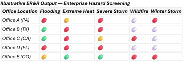
High = red
Medium = yellow
Low = green
None = white
Portfolio Assets (Private or Regional Public Sector): Relative Physical Risk Prioritization Across Assets
Context
An organization manages a portfolio of assets distributed across regions larger than a single county (e.g., regional or national). Assets are exposed to different physical hazards depending on location.
Screening Question
Within each hazard type, which assets show relatively higher physical risk exposure, and where is deeper, asset‑specific analysis most justified?
ER&R Contribution
ER&R provides hazard‑specific screening comparisons across the portfolio (e.g., wildfire risk relative to other wildfire‑exposed sites; hurricane risk relative to other hurricane‑exposed sites).
ER&R does not normalize or rank different hazard types against one another (e.g., wildfire vs. hurricane). It cannot determine whether one hazard type is “more significant” than another across locations; it evaluates relative exposure within each hazard category only.
Optionally, ER&R may reference Climate Mapping for Resilience and Adaptation (CRMA) data to show directional change over time within a given hazard category, strictly as contextual awareness—not forecasting.
Decision Value
- Identifies which assets warrant closer follow‑up within each hazard type
- Supports staged investment and analysis planning
- Provides a defensible baseline reference point for future comparisons
Community / County‑Scale Planning: Physical Hazard Awareness & Population Exposure Context
Context
A county or multi‑county region is preparing for resilience planning, emergency preparedness, or grant‑funded initiatives and needs clarity across numerous FEMA‑aligned datasets.
Screening Question
Which physical hazards currently present the most widespread exposure across the county, and where do higher‑priority hazard areas spatially coincide with population concentrations or critical service areas?
ER&R Contribution
ER&R synthesizes FEMA‑RAPT and related datasets to provide a county‑level hazard screening, with sub‑county (e.g., census‑tract) context introduced only where it materially improves understanding of spatial exposure patterns. ER&R characterizes where hazards and populations overlap, without evaluating asset condition, fragility, or social vulnerability characteristics.
Optionally, ER&R may reference Climate Mapping for Resilience and Adaptation (CRMA) to illustrate how federally published future‑oriented indicators compare to baseline conditions, supporting long‑term awareness in capital or adaptation planning.
Decision Value
- Focuses planning discussions on where exposure patterns are most consequential
- Supports scoping of downstream work (e.g., shelter analysis, capital planning, or more detailed studies)
- Helps decision‑makers distinguish current priorities from longer‑term considerations
Example Output
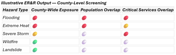
High = red
Medium = yellow
Low = green
None = white
Facility or Site Context: Location‑Specific Risk Awareness (Non‑Engineering)
Context
An organization is evaluating a specific facility, campus, or critical site and wants to understand the physical climate risk context of its location, without performing site‑specific analysis or design review.
Screening Question
Based on authoritative FEMA‑aligned datasets, which physical hazards are relevant in this location today, and are there future‑oriented indicators that leadership should be aware of at a screening level?
ER&R Contribution
ER&R summarizes what FEMA Resilience Analysis and Planning Tool (RAPT) and related datasets indicate about county‑ and sub-county (e.g., census‑tract) physical hazards applicable to the site’s geographic context. Where requested, CMRA indicators may be referenced to provide directional future awareness, without generating scenarios, predictions, or evaluations of facility resilience. ER&R does not evaluate building condition, compliance, or resilience; it provides context only.
Decision Value
- Informs leadership awareness and communication
- Helps determine whether engineering, design, or operational reviews are warranted
- Provides context without implying safety, suitability, or performance conclusions
Example Output
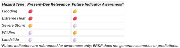
High = red
Medium = yellow
Low = green
None = white