Owner/Client
Lyons Run Watershed Association
Location
Murrysville, PA
CEC Services
- Erosion & Sedimentation Control/NPDES Permitting
- Geotechnical Engineering
- Site Grading/Earthwork Analysis
- Stormwater Management/BMP Design
- Clean Water Act, Section 401/404 Permitting
- Ecosystem Restoration
- Macroinvertebrate Surveys
- Water Quality
- Wetland AMD Treatment
- Wetlands & Waters Delineations
- Erosion & Sediment Control Design
- Stormwater BMP Design
- TMDL Calculations and Monitoring
- Watershed Planning and Restoration
- Aerial Photography/Videography
- As-built Surveys
- Construction Surveys/Staking
- Horizontal & Vertical Control Surveys
- LiDAR Surveys – Short and Long Range
- Review of Mine Mapping
- Topographic Surveys
- Unmanned Aerial Services
- Archaeological Investigations (SHPO 106)
- Architectural History Investigations (SHPO 106)
- GPS/GIS Services
- Construction Quality Assurance (CQA)
Owner Objective
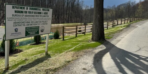
Lyons Run Watershed Association (LRWA) is a Pennsylvania non-profit focused on conserving and restoring local watersheds. They operate in Westmorland County and have acquired and conserved properties along high-quality watersheds. Three abandoned mine drainage (AMD) sources severely impacted the water quality and ecological function of the Lyons Run watershed. The project site and sources of the AMD were coal mined prior to the Surface Mining Control and Reclamation Act (SMCRA) of 1977, leaving a legacy of coal mining-related impairment with no liable owner. LRWA led the effort to design and construct a passive AMD remediation treatment system to reduce acid, iron, and aluminum contaminants in Lyons Run.
CEC Approach
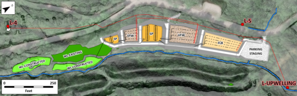
CEC prepared an engineering design to divert the three contaminated AMD sources into a successive alkalinity producing system (SAPS) to neutralize acid, collect precipitated solids, and improve watershed aesthetic and ecological function. Various site constraints resulted in a complicated engineering approach. These included minimal vertical relief for a gravity-driven system, delineated streams and functional wetlands, shallow aquifer hydrogeology impaired by AMD, the presence of a modeled 100-yr floodway, seasonal variations in discharge rate and contaminant loading, stormwater culverts diverted into the site, and the presence of additional unconsolidated acid seeps.
CEC completed baseline water quality sampling, ecological delineations, baseline biological monitoring, high resolution LiDAR topographic UAV flights, a geotechnical site investigation, and completed regulatory components including USACE, PADEP, and local requirements. CEC performed calculations for alkalinity generation rates, chemical oxygen demand, heterogeneous iron oxidation rates, precipitated sludge volumes, and best management practice sizing and retention.
Three AMD sources are directed into separate treatment components before recombining into “polishing” wetlands. Mine spoil underwent appropriate handling and alkaline amendment practices. The site was revegetated with native, noninvasive trees, shrubs, and herbaceous cover.