Owner/Client
Arkansas Department of Energy and Environment
Location
Charleston, AR
CEC Services
- Geotechnical Engineering
- Site Grading/Earthwork Analysis
- Stormwater Management/BMP Design
- Aquatic & Terrestrial Habitat Surveys
- Clean Water Act, Section 401/404 Permitting
- Ecological Risk Assessment & Land Restoration
- Waters Delineations
- Stream Restoration
- As-built Surveys
- Bathymetric/Hydrographic Surveys
- Mine Surveys and Mapping
- Cultural Resource Management
- NEPA Documentation
- LiDAR Topographic Survey and Photography
Owner Objective
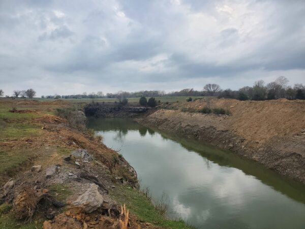
The owner of the project is the Arkansas Department of Environmental Quality’s (ADEQ) Mining Division. Coal mines that were operated prior to The Surface Mining Control and Reclamation Act (SMCRA) that was signed on August 3, 1977, are eligible to be reclaimed under the Abandoned Mine Lands program to remove hazardous features that pose a risk to the public. The mine had a stream entering one end and exiting the other, resulting in a hazardous water body that contained dangerous highwalls extending up to 30 feet high. The objective of this project was to remove the hazards and return the property to a safe and usable condition.
CEC Approach
CEC was awarded an on-call services contract from ADEQ through a Request for Qualifications process. The first two objectives of this project included preparing an Environmental Assessment (EA) and conducting a topographic survey of the land and a bathymetric survey of the hazardous water body. The CEC team delineated all streams and wetlands onsite and performed an ecological investigation of the site and surrounding areas to check for endangered species and potential habitat.
Following the survey and investigation, CEC completed an EA complying with the National Environmental Policy Act (NEPA). The EA process included consulting with state and federal agencies, including local Native American tribes, on behalf of ADEE. Once completed, the EA was reviewed and approved by the Office of Surface Mining Reclamation and Enforcement (OSMRE). In tandem with the EA, CEC completed the reclamation design to remediate the dangerous highwalls and hazardous water body associated with the abandoned coal mine. Our reclamation approach included backfilling the hazardous water body with onsite spoil material to a pond depth of 15 feet, then cutting back the remaining dangerous highwalls.
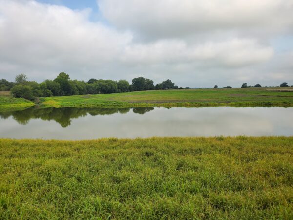
The final product was a farm pond with minimum 3 (horizontal): 1 (vertical) side slopes below the water surface and minimum 8:1 side slopes above the water surface. The stream and pond were modeled to confirm no adverse downstream impacts would occur due to the changes in the size of the water body. This resulted in the construction of an earthen weir at the outflow of the farm pond to maintain pre-construction flow conditions. Lastly, the disturbed area was reseeded to revegetate the area.