CEC provides a wide range of land surveying services with a full complement of cutting-edge technology, including 3D laser scanners using Light Detection And Ranging (LiDAR) scanning.
CEC utilizes the latest technology in terrestrial, mobile, and airborne 3D laser scanning with GPS to provide solutions to clients’ unique survey needs.
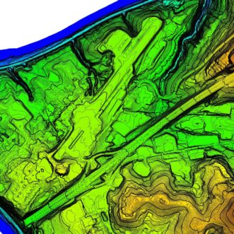
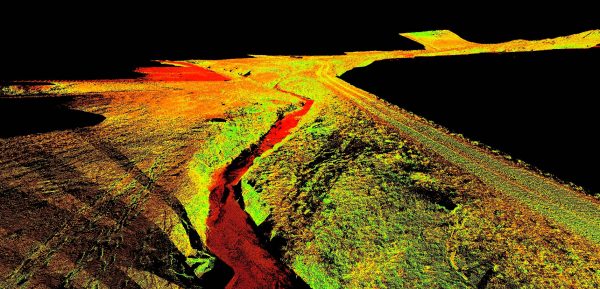
Using LiDAR, CEC can create an extremely detailed and dimensionally accurate 3D point cloud using millions of acquired intelligent data points on a project site. Downloaded directly to a laptop at the site, LiDAR can be used to derive a digital twin model capturing existing site conditions at the time of survey providing decision-making information.
Mobilization
 With ease of portability and setup, and decreased data processing and clean-up time, LIDAR scanning provides significant time savings versus traditional land surveying techniques. The use of LiDAR technology also enables increased safety by minimizing the need to send crews into dangerous spaces or high-traffic areas and roadways. Plus, the data can be revisited and new survey information can be retrieved based on client needs without remobilizing to the field. LiDAR systems fixed to UAS, airplanes, rotary aircraft, or passenger vehicles allows CEC to efficiently collect data over large footprints.
Broad Application
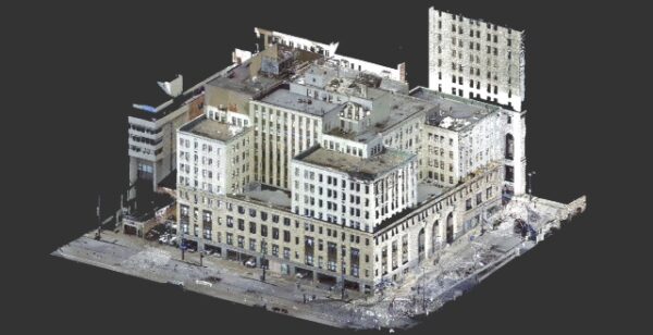 Through the use of LiDAR, CEC can efficiently capture high-definition field data that enhance a broad range of land surveying and engineering projects from architectural and building surveying to industrial mapping of intricate sites and structures to forensics and accident reconstruction.
- As-builts for architectural and commercial projects, industrial facilities, landfills, water treatment plants, power plants, electric substations, and oil and gas well pads and pipelines
- Horizontal and vertical clearances for roadways, bridges, and structures
- Detailed earthwork volumes and quantities
- Before-and-after dredging scans to calculate quantity for dry basins and ponds
- DOT surveys for traffic and highway structures, installations, and appurtenances
- Tunnel and mine scanning
- Topographic mapping & surface modeling
Technology
CEC utilizes both “Phase Based Scanners” and “Time of Flight Scanners.” The performance of these scanners can capture objects up to and more than 3,000 feet away, and in direct sunlight. Typical deliverables are intensely accurate and include:
- 2D CAD Data in plan, elevation, or cross-sectional view
- 3D CAD Data
- Animated fly-throughs of the point cloud
- Text, RCS, DXF, TIN, or XML file of the point cloud