CEC has the technology to scan existing structures or construction sites. We then provide you with highly accurate digital point cloud representations that offer invaluable insights for design, planning, and construction.
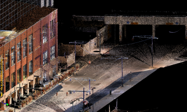 Imagine having a digital twin of your project – a precise 3D model that captures every intricate detail from the curvature of a façade to the texture of a stone wall. Reality Capture technology offers this and more. CEC has the technology to scan existing structures or construction sites. We then provide you with highly accurate digital point cloud representations that offer invaluable insights for design, planning, and construction. With Reality Capture, you can:
- Building Information Modeling (BIM) importation: Import CEC point clouds into your 3D models to capture existing conditions of the interior and exterior of buildings.
- Visualize your design concepts in real-world context: See how your architecture will interact with the surrounding environment.
- Identify potential challenges and risks early in the design process: Make informed decisions based on accurate data.
- Improve collaboration and communication: Share detailed 3D models with clients, contractors, and stakeholders.
- Reduce errors and rework: Ensure that construction aligns perfectly with your design intent.
- Create immersive virtual experiences: Give clients a realistic preview of their completed project.
- As-built documentation: Accurate measurements and details of existing structures for renovations or additions.
- Site analysis: Detailed assessment of terrain, vegetation, and existing features.
- Construction progress monitoring: Tracking project progress against design plans.
- Virtual walkthroughs: Immersive experiences for clients to visualize the final product before construction begins.
CEC can utilize land and air-based LiDAR technology for highly accurate reality capture. LiDAR, or Light Detection and Ranging, emits laser pulses to measure distance and create detailed 3D point clouds. These point clouds provide a precise representation of the existing environment, including terrain, vegetation, and structures. The resulting data can be imported into AutoCAD Revit, Recap, and SketchUp to support various architectural and engineering tasks, from site planning and design to construction monitoring and asset management.


