Civil & Environmental Consultants, Inc. (CEC) utilizes UAS to conduct site inspections, topographic surveys, construction site monitoring, stockpile and landfill volumetric calculations, vegetation analyses, optical gas imaging, and other similar projects. UAS provide a cost effective, low-environmental impact solution that optimizes the quality and value of collected data.
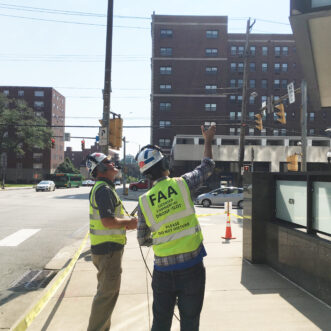
CEC obtained a Federal Aviation Administration (FAA) Section 333 Exemption and FAA Part 107 Pilot Certifications to operate robotic UAS within the national airspace system for the purpose of conducting aerial data acquisitions. The use of UAS enables CEC to conduct data acquisition for project sites in a safe manner. The use of UAS also creates significant economic efficiencies, such as reductions in the number of field personnel required and the time required for both data acquisition and review.
Applications of the technology include:
Aerial Photography / Topography
Armed with the ability to capture 20 megapixel or greater photos, or record 4K video from a unique vantage point, UAS can provide a data file typically containing 200 to 300 points per square meter. By comparison, a conventional aerial survey data file may contain up to only 50,000 points. Aerial photographs can be used to display time- lapse project progress, monitor remote locations, or provide photography to be used in presentations, displays, or advertising. A survey-grade UAS equipped with a built-in GNSS/RTK receiver can obtain orthomosaic / digital elevation model/topography accuracy of as low as 3 cm (1.2 in), even in the most inaccessible areas. Our fleet also includes a High Definition 3D LiDAR Sensor equipped UAS capable of capturing 1,500,000 points/second to create high accuracy topographic maps, even in vegetated conditions.
Methane Leak Detection – Optical Gas Imaging (OGI)
Utilizing innovative thermal imaging technology, CEC has the ability to detect very small fugitive emissions of greenhouse gases and other smog-forming volatile organic compounds. Through the marriage of our OGI camera and our UAS program, we are able to provide quick and safe detection and visualization of fugitive emissions leaks, allowing facility owners and operators to quickly detect and repair leaks, prevent major damage, and comply with local and federal regulations. CEC provides certified OGI Thermography Technicians to comply with EPA OOOOa reporting.
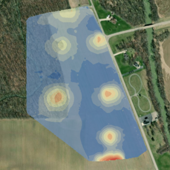
Vegetation Analysis, Precision Agriculture, and Impervious Surface Studies
Near-infrared (NIR) and multispectral cameras can be used to generate Normalized Difference Vegetation Index (NDVI) images for use in establishing vegetative cover percentages, which are necessary for close-out of NPDES and ESCGP-2 permits and the release of bonds in mining, among other uses. In agricultural applications, NDVI mapping can help maximize crop yields and assess environmental conditions for agriculture and environmental projects/permits. These images are then used to monitor soil composition and vegetative health, as well as measure and monitor plant growth, vegetation cover and soil/ water condition, and biomass production. Collected multispectral images can be spectrally classified in GIS by CEC’s experts to derive area calculations and land cover percentages of impervious surfaces in municipalities.
Thermal Imagery
UAS can be outfitted with infrared cameras capable of capturing thermal signatures from wastewater discharges from cooling towers, heat loss from buildings and equipment, groundwater seeps and springs, and other heat signatures.
Right-of-Way Monitoring
UAS can be used to visually monitor rights-of-way for both overhead and underground utilities to determine if revegetation efforts have been successful, if there is evidence of earth movements such as slumps and slides, if there has been unauthorized construction or storm damage, or if there is vegetative intrusion into overhead utility lines. UAS can be flown manually by an operator in visual contact with the UAS or pre-programmed to fly a specific flight path.
Geographic Information Systems (GIS)
The ability to shoot high-quality, geotagged photos allows for real-time GIS data acquisition and eliminates the need to contract aircraft or work around other schedules. Collected UAS imagery can be imported into CAD programs and GIS databases, or it can be stitched together to generate 3D reconstructions or develop topographic and aerial base mapping.
Visual Inspections
The ability to fly in close proximity to, and optically zoom in on, a target means that visual inspections of difficult-to-access objects or structures, such as stacks, bridges, reaction towers, pipe racks, etc., can be accomplished quickly and safely from a distance. High-resolution, HD-quality visual images can then be downloaded and electronically transferred to an array of users.
Volume Determinations
UAS can rapidly fly over raw material stockpiles and excavation areas to calculate volumes or to determine waste placement volumes at landfills and assess remaining available airspace.
Emergency and Disaster Response
Deploying UAS to capture photographs or video of an emergency or disaster scene prior to entry by first responders or investigators significantly increases safety and response planning. High-resolution aerial imagery from UAS integrates with traditional photogrammetry software to provide accurate, detailed information and long-lasting evidence.
Locating Orphan Wells
UAS can be used to locate orphaned wells by suspending dual sensor magnetometers from our aircraft. The aerodynamics of the magnetometer paired with the flight time of our aircraft helps efficiently assess and prioritize wells for abandonment and eliminate their environmental hazards.