A Multi-step, Multi-partner Collaboration to Combat a Harmful Algal Bloom in Lake Erie
In 2014, Lake Erie experienced a harmful algal bloom (HAB). Not all algal blooms are harmful, but toxins produced during the 2014 summer season not only harmed the local ecosystem, including fish, shellfish, marine mammals, and birds, but they also contaminated the City of Toledo’s drinking water, prompting a “do not drink” advisory for days. HABs pose multiple health risks to humans and local ecosystems, and HABs are also a concern due to their consequent effect on the health of local and regional economies. Communities around Lake Erie held numerous public discussions about what caused the problem and how to prevent it from happening again. But how were they to accomplish this?

First, they needed to gather useful data about the sources of the nutrients, specifically phosphorus, which is a large driver for a HAB occurrence, and identify relevant hotspots related to nutrient input throughout the Western Lake Erie Basin (WLEB) watershed. Conversations throughout the planning process identified a crucial need for a tool that the public could access and easily use to understand the nutrient sources. Second, an understanding of the sources could guide stakeholder communities to focus on critical areas and identify the actions needed within those areas to make progress toward nutrient reductions. Third, they’d need to start implementing projects identified in these critical areas in order to begin making progress towards reduction goals and, ultimately, a reduction in HAB occurrence in the WLEB. Most importantly, they knew there would be a long road ahead, as HABs are not easily buttoned up. Finding a long-term solution to the problem would likely take years and require collaboration from stakeholders across seven million affected acres.
Harnessing Data and Developing a Tool
The government of Lucas County, Ohio, which abuts Lake Erie on its western edge and is the fourth-largest county in Ohio by population, was compelled to take action. In June of 2015, the County’s Board of Commissioners and the Toledo–Lucas County Sustainability Commission engaged CEC to identify nutrient sources, as controlling these sources would help reduce algal blooms in the basin. The County Commissioners wanted the data to be specific and apolitical, allowing science to back up the processes to help people living in the basin. Tim Murphy, CEC’s Corporate Public Sector Market Group Lead, based in CEC’s Toledo office, helmed the effort. Murphy had previously served as the Environmental Commissioner for the City of Toledo for seven years and steered the city through the 2014 “Do Not Drink Advisory,” rendering him an ideal project lead.
CEC helped compile and present publicly available data through a user-friendly, interactive Geographic Information System (GIS)-based mapping tool called the Nutrient Source Inventory (NSI). The tool made location-based nutrient source information available to elected officials, stakeholder groups, and the general public so they could holistically understand the status of their watershed and make informed decisions about potential action items. CEC elevated the inventory by modeling the existing data to estimate the amount of nutrients coming from the potential identified sources, including wastewater treatment plants, National Pollutant Discharge Elimination System (NPDES)-permitted industries, combined sewage overflows, unsewered areas and failing septic systems, row crop agriculture, urban runoff, and livestock farms. The models helped identify smaller, sub-watershed areas within the larger watershed that may contribute larger amounts of nutrients than other land areas. The NSI also incorporated models that simulated nutrient reduction best management practices (BMPs) for agricultural lands (the dominant land use) in these sub-watershed areas to demonstrate the potential for nutrient reduction if landowners were to adopt those specific practices.

“CEC was open to our team of individuals from both the non-profit sector and government; both rural and urban communities. And CEC worked with members of the entire basin, not just people within the county. It was a representative group,” Lucas County Commissioner Tina Skeldon Wozniak says. “The NSI is comprehensive and easy to use, and has high-level policy-related components—it teaches people that this bloom is a factual problem and that something must be done about it. This is a tool to begin doing something.”
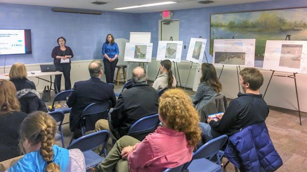
Murphy has given presentations on the NSI’s functionality at various events with the Mayor of the City of Toledo, County Commissioners and other elected officials, private entities, and interested community members present. The NSI has been used in local schools so that kids can explore it and learn from it. Lucas County hosted a webcast with all counties in the United States to showcase the tool’s features. The County Commissioners are using the NSI as a springboard for conversations with other municipalities to discuss its results and potential assistance in implementing BMPs where needed most. The overall nutrient reduction project is beginning to deliver on the need for HAB education, both locally and nationally.
You can check out the NSI on Lucas County’s website at http://www.lucascountygreen.com.
Writing Grant Applications and Developing Watershed Plans: A One-Two Punch
The City of Defiance marks the halfway point between the headwaters of the Maumee River in Fort Wayne, Indiana, and the mouth of the Maumee River in Lucas County. The Maumee River has the largest watershed of any river flowing into a Great Lake, and it is the sole source of the City’s drinking water. Like Lucas County, the City knew it needed to take action to protect its drinking water and reduce the potential for HAB development both in the Maumee near its intake and in its reservoir. Located in a rural area and centrally within Defiance County, the City identified itself as being in a unique position to be able to work with County officials and agencies, as well as with local farming communities.
CEC’s watershed planning team, led by Deanna Bobak, also of CEC Toledo, focuses on utilizing watershed-based planning tools to leverage state and federal grant funds to outline and implement a water-quality improvement strategy. Bobak’s extensive experience in watershed planning and restoration has included helping clients secure more than $2.2M in planning and implementation funding.
Bobak worked with the City of Defiance to develop a grant application for planning funding for a key sub-watershed directly upstream from the City. In partnership with the City, Bobak facilitated the development of a Nonpoint Source-Implementation Strategy (NPS-IS, also known as Nine-Element Plan) for the Platter Creek watershed. The NPS-IS developed with the City is just one of 38 approved plans for which Bobak has served as lead technical author—more than any other Nine-Element Plan writer based in Ohio.
NPS-IS plans are the key to opening the door to grant funding. Projects contained within approved plans become eligible to receive nonpoint source grant funds from Section 319 funds and other resources, such as the Great Lake Restoration Initiative. With a focus on nutrient reduction, the Platter Creek NPS-IS received approval in January 2020. The City—along with its partners the Defiance Soil and Water Conservation District (SWCD) and The Nature Conservancy—has already submitted one grant application for a BMP project contained within it.
Implementing Projects in Those Watershed Plans
“Because we’ve worked with so many organizations to get plans in place, once a plan is in place, they are already primed to go after implementation dollars for their improvement projects, a process that is fairly competitive,” said Bobak. Municipalities, SWCDs, and Non-Governmental Organizations (NGOs) across Ohio are key partners to implementing projects, and Bobak and Murphy applaud those entities they’ve been privileged to work with so far in aligning their needs with funding opportunities.
“We’re confident that we’ll see positive changes in our watershed after we can begin implementing projects in our Nine-Element Plan, but it also depends on participation levels with farmers signing up for programs,” said Jennifer English, MS4 Coordinator for the City of Defiance. How would they compel the region’s independent-natured farming communities?
“We’ll need to make sure farmers understand there are financial incentives to get on board,” said English. Projects that focus on BMP implementation help reduce the financial risk for producers to make changes within their operations for the benefit of nutrient reduction and improved water quality. In partnership with the City, the Defiance SWCD is a direct link to helping identify appropriate BMPs and enrolling landowners into these programs. SWCDs are the trusted advisors to the agricultural community and provide valuable advice in agricultural land management practices.
“Helping farming communities to understand the benefits of working with us on this is a generational issue,” English noted. “It won’t be solved overnight—in addition to education about the issues, we also need to do more future-friendly farming and regional food economy. We’ll need measurable impact with the blooms as well as participation from the farming communities in order to see the greatest impact. We’d like to get to the point where they ask, ‘How can I be part of this? How can I help?’”

Continued Work
The HABs in Lake Erie aren’t an isolated incident. According to the National Oceanic and Atmospheric Administration, HABs have been reported in every United States coastal state. They’ve also been reported in the Gulf of Mexico and elsewhere in the world, including Japan. “Because algal blooms are weather-driven, they’ll be a perpetual problem, especially with climate change,” English emphasizes. “This problem will need adaptive management—we need to work collaboratively, not only regionally, but also globally.”
At the state level, Ohio Governor Mike DeWine announced the $172M H2Ohio program in November 2019. This initiative to ensure safe and clean water for all Ohioans over the course of two years includes a goal of reducing nutrients. The State of Ohio, through its Domestic Action Plan, has a set goal of achieving a phosphorus loading reduction of 40% to the WLEB by 2025. The NSI, the Nine-Element Plans, and the ensuing projects are important steps in the process of reaching those goals, and collaboration across the entire WLEB watershed will remain a critical component to propelling additional progress.
Related Blog Posts
- Is Your Ohio Watershed Ready? (August 2, 2019)
- CEC Toledo Expands Watershed Planning, Ecological Sciences Capabilities With Addition of Jaimie Johnson (April 23, 2020)


Post a Comment